
After the storm, what next?
Whilst most places missed the worst of Storm Ciaran, it has been an ongoing story of rain and wind recently. Does the weekend offer any respite?
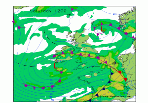 1 - More rain for England and Wales on Saturday: Another deep centre of low pressure will push a front northwards bringing more heavy rain to the southwest, south Wales then into the Midlands in the morning. This will extend further north and east into the afternoon. 10-20mm widely, with 25 to 40mm over high ground in the southwest which will raise the risk of flooding again.
2 - Windy in the south: But not as severe as Ciaran. Although the next low is notably deep, it doesn't have the same structure or squeeze on the isobars. It will bring strong to gale force gusts on the south coast, but nothing out of the ordinary. Strong winds will also affect Wales and up the east coast too as the low pushes north.
3 - Fine Saturday for Scotland: Apart from localised coastal showers in the north, much of Scotland will have a fine day on Saturday. Light winds, variable cloud and sun, possible fog patches at first. Northern Ireland too should get away with a half decent day.
4 - Average to cool temperatures: Under the rain over the Midlands, expect daytime values to be a rather unpleasant 7C. Elsewhere nudging to 9 or 10C, locally a little higher in the southwest. Sunday also stays in the range 8 to 12C. Overnight generally above 3 to 5C, but some rural spots in Scotland and Northern Ireland may see slight frosts this weekend.
5 - Westerlies return: Here's an unusual one lately, a full on westerly airflow over Britain and Ireland. Sunday takes low pressure back to the north and brings a mix of sunshine and showers - these mostly near to western coasts where locally heavy with risk of thunder. A scattering of showers extending inland, but staying drier in the east.
