

I mentioned in a recent Look Ahead video the updated analogues for winter and so I thought I'd quickly put together some thoughts here ... January Low pressure has consistently been a feature of the analog guidance for January 2026. This one is no different with the lower than average pressure to the
Musings
High pressure on the way

5 things for the coming weekend

🌤️ Mix of cloud and brighter spells, with sunshine breaking through at times 🌦️ Showers mainly in western areas, some lingering and locally heavier 💨 Breezy conditions, especially near coasts and higher ground ☁️ Cloud increasing later, turning rather dull in places ❄️ Chillier feel overall, particularly in the
A Swathe Of Rain In England Today
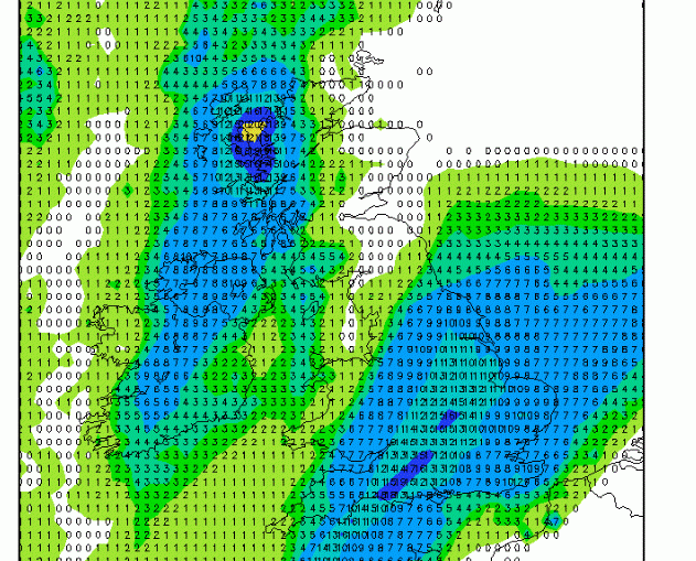
Several frontal boundaries will be crossing the British Isles today with one notable broad frontal structure brining persistent rain, often heavy, into England much of the day. I've clipped the 6-hour rainfall totals for 6pm today from the ECMWF model, shown below: Totals reaching the middle teens of millimeters across much
January 2026 Preliminary Weather Guidance

+++ THIS FORECAST IS FOR PRIVATE CLIENTS ONLY AND MAY NOT BE DISTRIBUTED OR COPIED IN ANY WAY WITHOUT PRIOR PERMISSION. +++ JANUARY 2026 - PRELIMINARY GUIDANCE =================================== Issued: Tuesday 16th December 2025 Contact: simon@weatherweb.net HEADLINES ========== + Cool + Early frost and fog + Colder later FACTORS AFFECTING JANUARY 2026 PRELIMINARY GUIDANCE ===================================================== + High pressure dominantes + After mid-month the high
5 Weather Things to Know For The Week Ahead
A wet week to come, a drier to follow..

Hello everyone A quick look at the two precipitation-anomaly maps (source: https://charts.ecmwf.int) tells a pretty clear story. For next week, the Atlantic is very much “open for business,” continuously feeding moisture into the region. That means fairly wet conditions for many areas, with frequent bouts of rain rather than long dry


