

Autumn rains continue to dominate the weather story... 41724
Musings
Restless Skies and Autumn Whispers: A Breezy, Changeable Week Ahead

Temperatures change

Good day everyone! We’re currently experiencing a fairly typical spell of November weather — the usual mix of bright intervals, cloudier periods, and of course, plenty of rain for many of us. Some areas will still catch a bit of sunshine, but overall it’s an unsettled pattern, exactly what we’d expect
5 things for the weekend

• ☁️ Mostly cloudy overall — limited sunshine but some brighter spells, especially Saturday.• 🌧️ Showers around — Ireland and western areas more prone to heavier bursts.• 💨 Breezy conditions — winds picking up at times, especially near coasts.• 🌡️ Mild for November — highs typically 12–15°C, cooler in the
How Did The GFS Model Do With Rainfall?
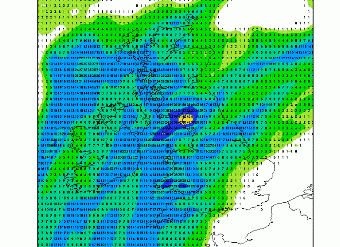
Below, I've screenshotted the tops 5 precipitation amounts for weather stations across the UK for the 24 hours ending at 6pm, Wednesday, November 5. How did the GFS model do at predicting these precipitation totals? As a reminder, here's the map I posted yesterday, which predicted the 36 hour rainfall totals
Short-Term Rainfall Totals
NAO changes ahead?

An interesting NAO forecast from the CFS via Kyle Macritchie's site. Look how we are positive now (hence stronger westerly winds across the Atlantic), but then see what happens from late November and into December and January. The index goes negative. This is a signal for less strong westerly winds, an easterly
5 Weather Week Things To Know

Rainfall Levels Forecast

Good day all! Below you can see the rainfall anomaly from the normal levels, for the next three week (source: charts.ecmwf.int).That clearly indicates that during the first week of the forecast, we will see higher than normal values, while the precipitation decreases during the very next two weeks. That can be
October 2025 Weather Guidance – Final Update

+++ THIS FORECAST IS FOR PRIVATE CLIENTS ONLY AND MAY NOT BE DISTRIBUTED OR COPIED IN ANY WAY WITHOUT PRIOR PERMISSION. +++ NOVEMBER 2025 - FINAL GUIDANCE ============================== Issued: Friday 31st October 2025 Contact: simon@weatherweb.net HEADLINES ========== + Unsettled start + Tending to become drier from east after mid-month + Possible misty, murky, colder end FACTORS AFFECTING NOVEMBER 2025 FINAL